DIGITAL AGRICULTURE PLATFORM ECOSYSTEM (VDAPES)
The Industry 4.0 Revolution has created many opportunities to apply high-tech products to agriculture, gradually building an intelligent agricultural system that adapts quickly to the complex climate change situation. This intelligent agricultural system setup has helped to enhance productivity and quality of food production, actively supporting our food security amidst rapid climate change.
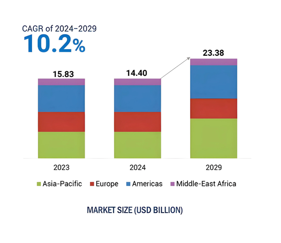
The average annual growth rate (CAGR) of the smart agriculture market globally from 2024 to 2029 is expected to be around 10%. Additionally, the market is estimated to grow from around USD 14.4 billion in 2024 to USD 23.38 billion in 2026.
Smart Agriculture will be highly relevant and important in the upcoming years.
Fig 1. Change in the market size of the smart agriculture market (Source: Markets and Markets, 2025)
In light of this agricultural revolution, many companies globally have been researching, developing, and investing in ways to integrate technology into agricultural management. For example, in June 2020, the Prime Minister of Vietnam signed Decision 749/QD-TTg, approving the National Digital Transformation Program until 2025, with a vision towards 2030, aiming to develop a digital government, digital society, and digital economy.
Taking advantage of the development of technology and the support of policies and legal frameworks, RYNAN® Technologies Vietnam has successfully researched and implemented the Vietnam Digital Agriculture Platform Ecosystem (VDAPES).
What is VDAPES?
The VDAPES is meant to provide a comprehensive Software as a Service (SaaS) platform for users to monitor and manage different key agricultural parameters, so that they can have a deeper understanding of the agricultural value chain. It is not only for the farmers, but also for the government, the enterprises, and the scientists.
What makes this digital agriculture platform system unique is the ability to gather large quantities of agricultural data from many sources, process and connect them into a centralised digital platform that is easy for users to navigate. Many technologies are utilized to create and support this platform, including the Internet of Things (IoT), Artificial Intelligence (AI), and Remote Sensing.

This successful combination of technologies to form an extensive Integrated Network has been termed SAGWIN (Space-Air-Ground-Water Integrated Network), effectively covering almost every environment on Earth and beyond. All the captured data from remote sensing and IoT devices is centralised and synchronized with one another in real-time on the VDAPES platform. Users are able to monitor different environmental factors simultaneously to form valuable and sensible relationships between the different factors. For example, they can access the insect population density data from the smart insect monitoring network, the RYNAN smart water quality monitoring network, and wind patterns from the weather sensors altogether via the VDAPES platform.

Fig 2. Insect population data from the RYNAN Insect Monitoring System that users can access and use in the VDAPES platform
This is very important in shaping how farming cooperatives, farmers, governments, and other stakeholders in their farming operations. The quality of agricultural production is highly dependent on many factors, so the regulation of just one of them at any given time point is insufficient. Simultaneously, factors like wind speed and direction affect the movement of flying crop pests, possibly shifting them to areas rich in crop plantations and new crop damage. A platform like VDAPES addresses this important issue.
VDAPES Case Study
Implementation of VDAPES has been explored in the Southern region of Vietnam, where RYNAN® Technologies originated from. The remote sensing technology was able to map out a rice cultivation map that provided users the data about rice farming areas by age every 12 days throughout the region. In addition, the AI algorithm made the forecast for the next 12 days or 24 days. Each color on the map represents a specific age group of rice, such as 0 - 12 days old, 13 - 24 days old, etc ( Fig.3 ).
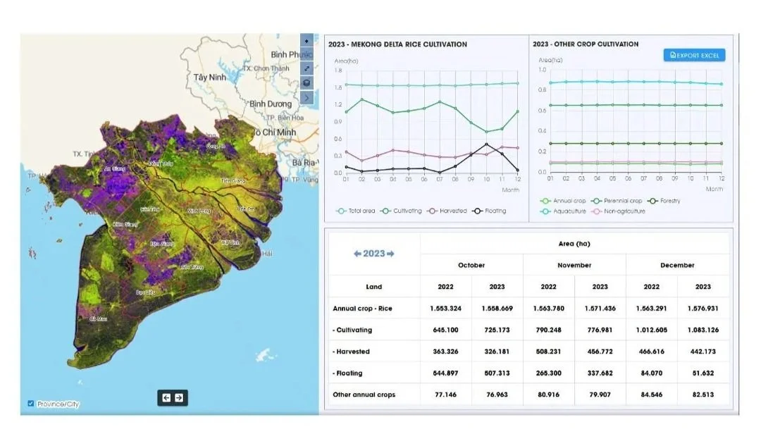
Fig 3. Rice cultivation map in Southern Vietnam, mapped out by VDAPES
In the Dong Thap province, RYNAN® Technologies trained approximately 5,000 users, including officers, enterprises, and farmers. Organizations like the Dong Thap Agricultural and Rural Development Department, the Dong Thap Natural Resource and Environment Department, and a few hundred more were involved in this VDAPES implementation. Positive contributions and feedback were received from the users, and RYNAN® Technologies will be working on improving the operations and design of the platform using the feedback received.

Fig 4. Presentation of the VDAPES platform to key stakeholders in the Dong Thap Province
VDAPES has the ability to help the authorities manage data across all sectors of agriculture, including crop cultivation and protection, livestock and veterinary, aquaculture, rural development, irrigation, and forestry. It allows for easy management across the different layers of the agricultural value chain, and this can shape how production is operated. Enterprises or the government working on large-scale agriculture or aquaculture projects can look at forestry layouts of land plots to shape the planning design of where the fields and farms are to be located optimally.
“The future of food security will depend on a combination of the ecological prudence of the past and the technological advances of today.”
With the success of its initial rollout, RYNAN® Technologies is set to bring this innovation to the international stage. The platform is designed to deliver measurable value across every layer of the agricultural value chain, offering a scalable solution that strengthens productivity and sustainability worldwide.
If you are interested in finding a comprehensive, accurate, and effective way to manage your agricultural value chain, contact us at:
https://rynanagriculture.com/rynan-dapes